Anomaly detection in small-scale industrial and household appliances
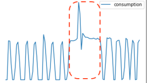 Anomaly detection is concerned with identifying rare events/observations that differ substantially from the majority of the data. It is considered an important task in the energy sector to enable the identification of non-standard device conditions. The use of anomaly detection techniques in small-scale residential and industrial settings can provide useful insights about device health, maintenance requirements, and downtime, which in turn can lead to lower operating costs. There are numerous approaches for detecting anomalies in a range of application scenarios such as prescriptive appliance maintenance. This work reports on anomaly detection using a data set of fridge power consumption that operates on a near zero energy building scenario. We implement a variety of machine and deep learning algorithms and evaluate performances using multiple metrics. On the analyzed dataset, we were able to identify anomalies with an F1 score of up to 78%. The final goal is to Implement an anomaly detection framework as a stand-alone component being able to function with any data input. This will allow this work to be incorporated as part of an analytics engine or any energy-related framework.
Water and Snow Monitoring with public web content
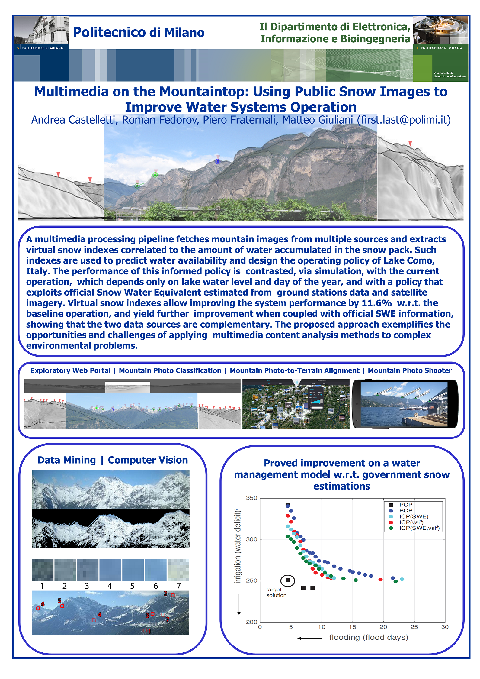 The Alps are the highest and most extensive mountain range system that lies entirely in Europe. The climate changes have a deteriorating impact on the region, negatively affecting the ecosystem and population of 14 million people spread across eight countries. The problem is worsening with recorded annual average temperatures increases and precipitation levels decreases. At the same time, ground monitoring infrastructures have not been updated, due to the need of high investments. This calls for novel instruments for the low-cost, high resolution, high accuracy monitoring of the dynamics of environmental events and condition in mountain regions, especially in the Alps. The Snow Use Case provides a solution by improving the capillarity of mountain environment monitoring by applying advanced image processing workflows to extract useful environment information from large collections of publicly available mountain related multimedia data. The solution we are pursuing is an original method to derive at scale information on mountain snow coverage from massive public web content (user generated photos and images captured from touristic web cams). The method uses an image processing workflow that aligns the picture taken by the user or crawled from a touristic web cam to a synthesized rendered view of the terrain that should be seen from the camera point of view; the synthetic panorama is generated by a projection applied to a (publicly available) Digital Elevation Model (DEM) of the Earth . This supports decision-making in a snow dominated mountain context, e.g., the prediction of water availability from snow coverage in the mountain peaks. Content acquisition and processing rely on crawling geo-located images from heterogeneous sources at scale. The proposed approach elaborates content by assessing the presence of mountains in each photo, identifying individual peaks, and extracting a snow mask from the portion of the image denoting an identified mountain. Architecturally, the system is distributed between several data centres. The alignment step is computationally intensive, so it is best executed by GPUs. The alignment operation must be executed for every acquired image. In particular, the image analysis workflow extracts the skyline for an image taken in uncontrolled conditions, and thus must implement a multi-stage, GPU-intensive sequence of steps, including image normalization, jitter compensation, occlusion detection, and skyline extraction. Given the massive amount of images to be processed to monitor the entire Alpine region over a long period of time (in the order of millions of images per year), the workflow must be deployed on a massively scalable, GPU-enabled architecture.
Illegal Waste Dumps Detection with aerial images

The research aims at introducing Geospatial Intelligence and Earth Observation technologies from satellite, aircraft and drone to counter illegal waste management through a more effective identification of situations of potential non-compliance with environmental regulations. Geospatial Intelligence is the process of acquiring knowledge of human activities from the analysis of georeferenced information and, in particular, of information derived from the Earth Observation from satellites, aircrafts and drones. It has recently been introduced by the European Commission in the context of environmental protection. In 2018, the EC created an Action Plan for increasing compliance with EU environmental legislation and improving governance. The Action Plan considers GI a new form of environmental compliance control and also a tool for targeting inspections to sites of interest in a more effective manner. Through GI, clues of violation of environmental regulations in authorized waste treatment plants are acquired and totally illegal situations such as those of uncontrolled waste deposits or illegal landfills are also identified. The research work has identified for the aerial image classification task the ResNet-50 model (ResNet: Residual Neural Network), one of the most consolidated Deep Learning algorithms, with the aim of predicting whether in a remotely sensed image there are potentially critical sites. ResNet-50 was subjected to a learning process based on about a thousand positive cases and an almost double number of negative cases. The peculiarity of the approach in the training of ResNet-50 is that it is holistic. It means that the classification model has been trained not to focus only on the single details of interest present in an image (for example: piles of waste, bins, cisterns, etc.) but to analyze an image in its entirety, behaving therefore in a very similar way to a human photo interpreter. The advantage of the holistic approach is to be able to identify critical situations, even very complex ones, with a high level of success and which had never been presented before to the classification model. The obtained model is capable of detecting potentially dangerous sites in aerial images with an accuracy approaching 90%. The ongoing research also aims to estimate the degree of danger of the sites identified and in the future also to indicate the presence of specific types of polluting or dangerous materials.